Argentina

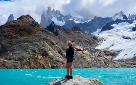
From the landscapes along the way to the feeling of standing at the top, looking out over Laguna de los Tres, this is the kind of place that stays with you long after you leave Patagonia.
That said, this hike is long, demanding, and not something you want to go into unprepared.
After doing it myself, I learned so much along the way, so I’m putting everything you need to know into one place to help you plan your hike as smoothly (and enjoyably) as possible.
The classic hike to Laguna de los Tres (the end point for the Fitz Roy Hike) takes around eight to ten hours in total, depending on how fast you walk and how long you stay at the top.
What makes this hike challenging isn’t one single moment, but rather the combination of distance, elevation, and that final steep section right before the lagoon.

It’s officially classified as a hard hike, but I don’t think that should scare you off. You don’t need to be an extreme hiker.
If you’re reasonably fit, willing to take breaks, and properly equipped, this is absolutely doable.
I saw people of all ages and fitness levels along the trail, all moving at their own pace.
The Fitz Roy hike starts in El Chaltén, a tiny mountain town that’s often called the hiking capital of Patagonia.
It’s a town built around people wanting to hike in the area, so it‘s a pretty touristy town with hotels and restaurants, but still very charming.
Just expect higher prices and lots of hikers everywhere.
You can’t fly directly to El Chaltén, so most people start by flying to El Calafate, either from Buenos Aires or Ushuaia. From there, it’s about a two to three hour bus ride into the mountains.
I always use Skyscanner to compare the best deals and prices for my flights. You can easily check prices for your travel dates here.

Buses run several times a day, but if you’re visiting during high season, make sure to book ahead.
I usually use BusBud to book all my busses in South America and highly recommend them. You can see the timetable for busses to El Chaltén here.
I made the mistake of booking the same day and almost everything was sold out. I luckily got a ticket, but it was ridiculously expensive.
At that point I was just happy to get there.
So learn from my mistake and book in advance.
Many people also choose to rent a car to have more flexibility when they explore Patagonia.
Whether or not you need a car really depends on how long you’re staying and how many hikes you want to do.
Many hikes will take you back and forth to the city itself, but for some you’ll need your own car or have preplanned a pickup/drop of.
The pickups are quite expensive in itself, so if you know you're going to need a lot of it, renting a car is an easier and more budget friendly alternative.

Find the best deals for your travel dates

Every now and again I'll send you my latest travel updates and guides.

There are two main ways to do the Fitz Roy Hike and choosing the right one can really shape your experience.
Both lead to the same final viewpoint at Laguna de los Tres, but the experience is quite different.
This is the most common and straightforward option and therefore why most people choose this one.
The trail starts right in town, which means you don’t need any pre-booked transport and therefore have complete flexibility with timing.
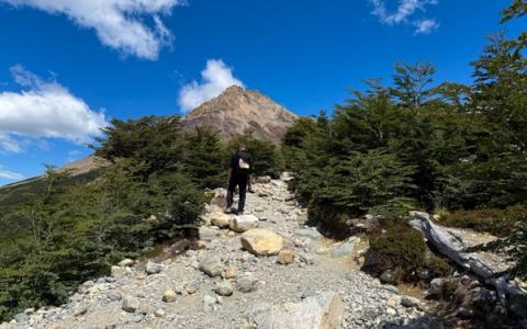
The downside is that the hike begins with a very steep and boring climb.
The first hour is almost entirely uphill with hardly any views, and it’s a tough way to start the day.
After that, the trail flattens out and becomes much more manageable for a couple of hours, until you reach the campsite where both routes eventually meet.

Compare the latest flight prices and find the best deals here.
From there, you face the final climb, which is about an hour of very steep, narrow trail.
This part is physically demanding and also where the crowds really show.
People are moving slowly, others are coming back down, and you sometimes have to wait your turn to pass.
If you choose this route, you’ll hike the exact same way back to El Chaltén.
This is in my book a downside since there is so much stunning nature to see in the area.

I always set up an eSIM before flying so I'm connected the moment I arrive. Compare the best plans from Airalo here.
If you want the most scenic and balanced experience, this is the route I recommend.
For this option, you’ll need to book a transfer to the trailhead at Rio Electrico, which our hotel in El Chaltén arranged for us.
My guess is that every hotel will be able to arrange this for you.
When we did the hike in January, the transfer cost was around 70USD per person.
It’s not cheap, but for me, it was worth it to get to see more of the area instead of hiking up and down the same route.

If you have your own car, you can just park at one of the many spots near the trail head.
You just have to walk back here to pick up the car instead of walking straight back to the city like we did.
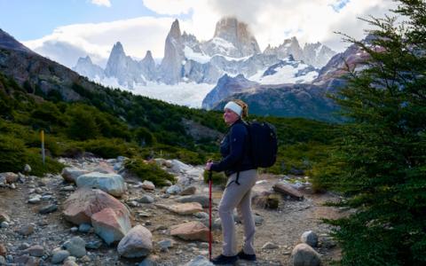
The hike starts gently, with about an hour and a half of mostly flat walking along the Rio Electrico and Rio Blanco.
Instead of immediately fighting gravity, you ease into the day, which makes a big difference mentally and physically.
As the trail continues, you get more uphill sections, but nothing extreme.


What really makes this route special are the views.
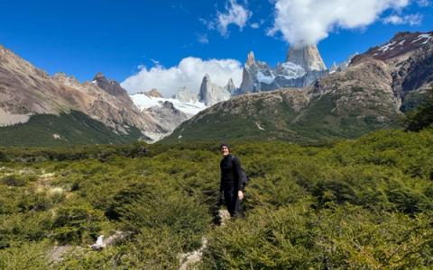
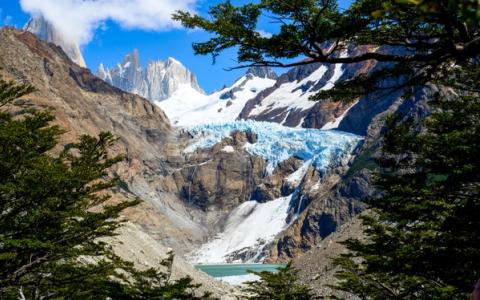
You will walk past the Glacier Piedras Blancas and you see Fitz Roy from a completely different angle, with wide open landscapes and viewpoints that most people miss unless they do a separate hike.
It felt quieter and more spacious.

Browse the highest-rated tours and experiences here.
Eventually, this route joins the main trail at the campsite, and from there you climb the final steep section together with everyone else.
The big difference comes afterward: instead of turning around and walking the exact way back, you continue all the way down to El Chaltén and finish in the city.
We stayed at Pudu Lodge, which is located very close to the trail-end, and I couldn't have been happier about choosing this hotel when we came down from the trail and didn't have to walk trough the city to rest.
That brutal uphill from the town route? It’s downhill for you.
If you want to see as much as possible and save some energy early in the hike, this is the route to choose.
The only downside is that you need to splurge on transport to the starting point.
This is also an alternative if you’re unsure if you will be able to make the full hike. We met a man on the trail towards the top that said he wasn’t fit enough to do the full climb.
However, he he couldn’t imagine the views getting that much better than the ones he saw on the way, so he would just walk as long as he could and turn around when it suited him.


I do of course think the views were the best at the top.
But if you're hesitant to do the full trek, then doing this route, and instead of climbing to the top, you can turn towards El Chalten before the steepest part is absolutely an option.

I personally use SafetyWing and highly recommend it for every kind of trip. Check their prices & plans here.
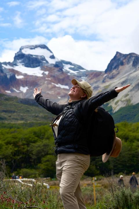
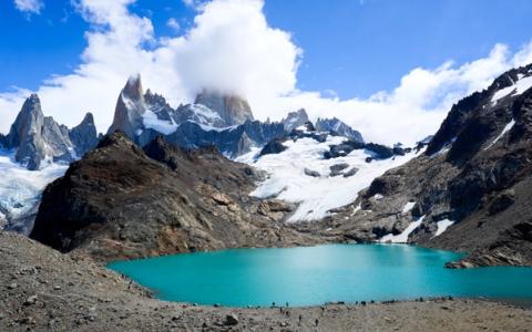
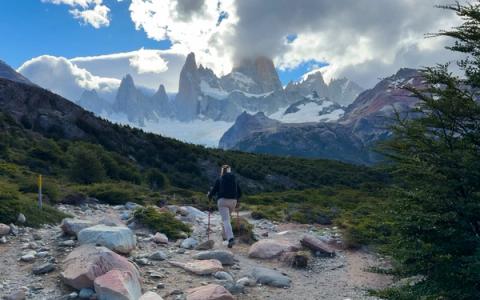
When you reach Laguna de los Tres, you’ll probably feel like you’ve reached the end, and technically, you have. But don’t stop there.
On the left side of the main lagoon, there’s a short climb to another viewpoint that most people miss.
It doesn’t look like much at first, and many hikers are too tired to bother.
But if you walk up just a little further, you’ll find another lagoon called Laguna Sucia and a stunning view that, in my opinion, is almost even more beautiful than what's supposed to be the main attraction.
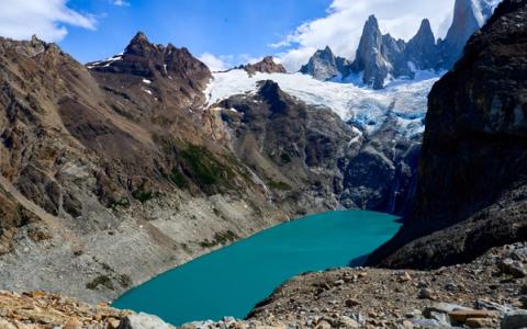
I hadn’t read about it anywhere and just followed a few people walking up there and I’m so glad I did.
Look for Mirador à la Laguna Sucia on Google Maps and you’ll see where it is and how close it is.

'%3e%3cpath%20d='M47.04%2025.9043H0.959961V37.3329H47.04V25.9043Z'%20stroke='%23987F61'%20stroke-width='2'%20stroke-linecap='round'%20stroke-linejoin='round'/%3e%3cpath%20d='M7.67988%2037.333H2.87988V43.0473H7.67988V37.333Z'%20stroke='%23987F61'%20stroke-width='2'%20stroke-linecap='round'%20stroke-linejoin='round'/%3e%3cpath%20d='M45.1203%2037.333H40.3203V43.0473H45.1203V37.333Z'%20stroke='%23987F61'%20stroke-width='2'%20stroke-linecap='round'%20stroke-linejoin='round'/%3e%3cpath%20d='M42.2399%2020.1904H5.75992C3.64792%2020.1904%201.91992%2021.9047%201.91992%2024V25.9047H46.0799V24C46.0799%2021.9047%2044.3519%2020.1904%2042.2399%2020.1904Z'%20stroke='%23987F61'%20stroke-width='2'%20stroke-linecap='round'%20stroke-linejoin='round'/%3e%3cpath%20d='M39.3598%204.95215H8.6398C6.5278%204.95215%204.7998%206.66643%204.7998%208.76167V20.1902H43.1998V8.76167C43.1998%206.66643%2041.4718%204.95215%2039.3598%204.95215Z'%20stroke='%23987F61'%20stroke-width='2'%20stroke-linecap='round'%20stroke-linejoin='round'/%3e%3cpath%20d='M18.2396%2012.5713H12.4796C10.3676%2012.5713%208.63965%2014.2856%208.63965%2016.3808V20.1903H22.0796V16.3808C22.0796%2014.2856%2020.3516%2012.5713%2018.2396%2012.5713Z'%20stroke='%23987F61'%20stroke-width='2'%20stroke-linecap='round'%20stroke-linejoin='round'/%3e%3cpath%20d='M35.5199%2012.5713H29.7599C27.6479%2012.5713%2025.9199%2014.2856%2025.9199%2016.3808V20.1903H39.3599V16.3808C39.3599%2014.2856%2037.6319%2012.5713%2035.5199%2012.5713Z'%20stroke='%23987F61'%20stroke-width='2'%20stroke-linecap='round'%20stroke-linejoin='round'/%3e%3c/g%3e%3cdefs%3e%3cclipPath%20id='clip0_42_2225'%3e%3crect%20width='48'%20height='48'%20fill='white'/%3e%3c/clipPath%3e%3c/defs%3e%3c/svg%3e)
Browse the best hotels, guesthouses, and boutique stays on Hotels.com here.
I was genuinely surprised by how many people attempted this hike in sneakers. Yes, it’s possible but it didn’t look comfortable.
The trail is rocky, uneven, and slippery in places, and proper hiking shoes make a huge difference, especially on the way down.
Water and food are essential.
We brought plenty of snacks and even carried a celebratory beer and chocolate for the top.
Our hotel prepared lunch boxes for us, which was perfect.
Standing at the lagoon, eating lunch after that final climb, is a moment I won’t forget.
Layers are absolutely non-negotiable.
I started the hike in shorts and a t-shirt under a clear blue sky.
By the time we reached the top, I was wearing a wool sweater, a warm jacket, hat, gloves, and later changed into long pants.
The wind at the top can be freezing cold, even on a sunny day. And if the weather turns, temperatures drop fast.

One thing people often forget is toilet paper.
There are bathrooms at the campsite, but no paper.
And if you need to go elsewhere, you’ll want to be prepared.
Always bring a plastic bag to pack all your rubbish in, nothing should be left on the trail.
I also borrowed walking sticks from our hotel. I'd never used them before and wasn’t sure I needed them, but they helped so much.
Especially on the long descent, my knees were very thankful. However, this might not be something you need, it’s a personal preference. Adrian didn't use them and didn't feel like it would have made a difference for him.
At the campsite where both routes meet, you’ll find bathrooms and a natural resting point before the final climb.
Slightly higher up, there’s a popular area where many people stop to eat before tackling the steepest section or celebrate afterwards.
You’ll also cross several streams along the way and I saw many hikers refilling their water bottles here. I didn’t personally do it, but it seems to be common practice.
I thought this hike would be impossible to mess up. Just follow the trail, right? Somehow, we still managed to walk off the path twice.
Not in a dramatic, lost-in-the-wilderness way, but enough to realize we weren’t where we were supposed to be.
The trail is marked with wooden sticks so if you ever feel like you haven’t seen one in a while, stop.
Go back to the last marker and look again.
Both times we went a direction that felt “logical” and both times it was wrong.
If the path stops looking well-walked, you’re probably off track.
This is one of the most popular hikes in Patagonia, and there’s really no avoiding the crowds.
If you want the best chance of fewer people, you’ll need to start before sunrise or sleep at the campsite near the top.
Otherwise, expect to walk in line, especially during the final climb
The trail is narrow, people move slowly, and hikers are coming down at the same time as you're going up.
It can be frustrating, but once you accept it and focus on the scenery, it becomes part of the experience.
We stayed at Pudu Lodge, and I honestly couldn’t have asked for a better base. After a long hike, coming back to a warm, cozy place matters more than you think.
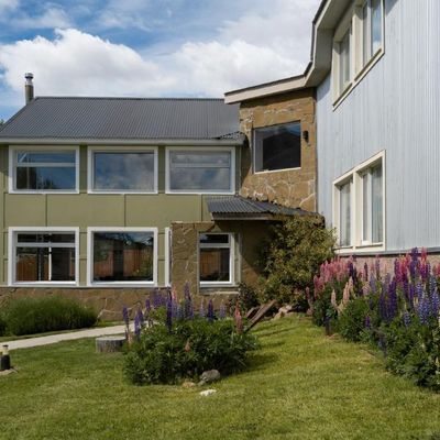
If you're looking for a comfortable, cozy place without breaking the bank, this is one of the best options in El Chaltén. It's located just a short walk from the trails and city centre, and offers spacious rooms and very comfortable beds. the staff is also very friendly and helpful.
Check prices and availability
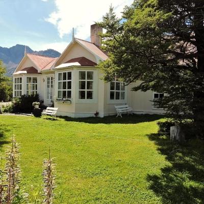
Unlike most hotels in town, it's located just outside El Chaltén near the start of several famous hiking trails, including Laguna de los Tres. Waking up surrounded by Patagonia's incredible scenery is a unique experience, and you'll beat the crowds by starting your hikes right from the hotel.
Check prices and availability
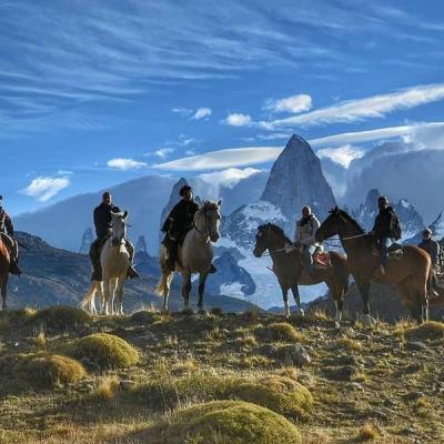
If you're looking for a truly unforgettable stay it doesn't get much more special than this. The luxury estancia is surrounded by mountains, forests, rivers, and incredible views of Mount Fitz Roy. Rather than simply booking a hotel, you're booking an authentic Patagonian experience.
Check prices and availability
If you’re going to Patagonia, this is not a hike I would skip. It’s long, it’s challenging, and at times it pushes you — but the reward is something truly special. Standing at the top, looking out at Fitz Roy and the lagoon below, makes every step worth it.
Hopefully this guide has given you everything you need to plan an unforgettable trip to El Chaltén. To make planning even easier, I've included all the resources I personally use when I travel.
Every recommendation is based on tools and services I genuinely use and would recommend to friends and family.
By using these links you help me continue to create free travel guides like this one.
Thank you for supporting Travels with Ingrid!
If you have any questions about travel in Argentina, or just want to follow along as I travel the world full time, don‘t hesitate to reach out to me on social media.
I would love to connect and help out!
-Ingrid